


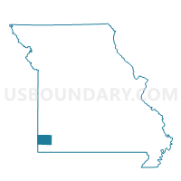
Staples Voting District, Newton County, Missouri
About
Outline

Summary
| Unique Area Identifier | 609222 |
| Name | Staples Voting District |
| County | Newton County |
| State | Missouri |
| Area (square miles) | 21.18 |
| Land Area (square miles) | 20.93 |
| Water Area (square miles) | 0.25 |
| % of Land Area | 98.81 |
| % of Water Area | 1.19 |
| Latitude of the Internal Point | 37.03921150 |
| Longtitude of the Internal Point | -94.54871240 |
Maps


Graphs
Select a template below for downloading or customizing gragh for Staples Voting District, Newton County, Missouri


Neighbors
Neighoring Voting District (by Name) Neighboring Voting District on the Map
- Galena Ward 2, Cherokee County, KS
- Garden Township Stanley Mine Voting District, Cherokee County, KS
- Hornet Voting District, Newton County, MO
- JOPLIN 15 \ CENTRAL CITY Voting District, Jasper County, MO
- JOPLIN 22 \ JOPLIN 26 Voting District, Jasper County, MO
- JOPLIN NO. 13 Voting District, Jasper County, MO
- JOPLIN NO. 25 Voting District, Jasper County, MO
- Reding Voting District, Newton County, MO
- REX Voting District, Jasper County, MO
- Thurman Voting District, Newton County, MO
Top 10 Neighboring County Subdivision (by Population) Neighboring County Subdivision on the Map
- Joplin township, Jasper County, MO (42,173)
- Galena township, Jasper County, MO (27,239)
- Shoal Creek township, Newton County, MO (12,829)
- Five Mile township, Newton County, MO (4,073)
- Galena city, Cherokee County, KS (3,085)
- Garden township, Cherokee County, KS (3,045)
Top 10 Neighboring Place (by Population) Neighboring Place on the Map
- Joplin city, MO (50,150)
- Galena city, KS (3,085)
- Duquesne village, MO (1,763)
- Leawood village, MO (682)
- Silver Creek village, MO (623)
- Shoal Creek Drive village, MO (337)
- Saginaw village, MO (297)
- Redings Mill village, MO (151)
- Grand Falls Plaza town, MO (114)
- Dennis Acres village, MO (76)
Top 10 Neighboring Unified School District (by Population) Neighboring Unified School District on the Map
- Joplin R-VIII School District, MO (59,509)
- Carl Junction R-I School District, MO (15,576)
- Seneca R-VII School District, MO (8,756)
- Diamond R-IV School District, MO (5,638)
- Riverton Unified School District 404, KS (3,873)
- Galena Unified School District 499, KS (3,644)
Top 10 Neighboring State Legislative District Lower Chamber (by Population) Neighboring State Legislative District Lower Chamber on the Map
- State House District 128, MO (38,369)
- State House District 129, MO (36,595)
- State House District 131, MO (36,451)
- State House District 1, KS (20,329)
Top 10 Neighboring State Legislative District Upper Chamber (by Population) Neighboring State Legislative District Upper Chamber on the Map
Top 10 Neighboring 111th Congressional District (by Population) Neighboring 111th Congressional District on the Map
Top 10 Neighboring Census Tract (by Population) Neighboring Census Tract on the Map
- Census Tract 109, Jasper County, MO (6,531)
- Census Tract 205.02, Newton County, MO (5,638)
- Census Tract 105, Jasper County, MO (5,205)
- Census Tract 206.01, Newton County, MO (5,012)
- Census Tract 104, Jasper County, MO (4,913)
- Census Tract 205.01, Newton County, MO (4,005)
- Census Tract 9585, Cherokee County, KS (3,854)
- Census Tract 9584, Cherokee County, KS (3,819)
- Census Tract 107, Jasper County, MO (2,825)